Wednesday, July 17, 2013

A big difference between recent blazing Summers and this one

I noticed something huge, as big as the West Pacific Ocean that is different than previous summers. Take a look a the water vapor filling the whole region.  Satellite images are from the University of Wisconsin SSEC.


Now take a look at June 2011 (last year was the same but there were no good shots.


The dark area in the middle latitudes was built by a strong jet stream.  The subsequent mega-ridge was a persistent feature for more than a year, disrupting weather patterns worldwide by locking extremes in place.

While the weather is never based only on 1 factor.  It is great to take a feature off the table that literally fried us, 3 out of the past 4 summers.

Thursday, June 6, 2013

What does TS Andrea and a Winter Storm have in common?

The neat thing about TS Andrea is that there is nothing I can tell you about the track, expected rainfall, ...etc... that has not been consistently forecast.  However, take a look at this evening's  satellite image courtesy of the University of Wisconsin SSEC.


There are many reasons to be awed by the weather. Take a look at the overall size of TS Andrea (1) and the involvement of the other two non-tropical systems.   The hybrid/baroclinically enhanced nature of Andrea is apparent as she maintains a banded structure in her NW and NE quadrants yet has an impressive warm front, a dry slot and a trailing frontal system still drawing heat and moisture from the deep tropics.

The trailing storm system (2). is being drawn into Andrea's structure much like a typical upper low that shadows major winter storms.  System #3 is a typical leading system that provides a trailing front that paves the way for heavier system.

There is no doubt that we are in for several inches of rain along and near the track. 

Tuesday, June 4, 2013

It is time to start posting again!

I really did not go anywhere.  Sometimes transitions in life can derail person from hobbies and interest. There will definitely be much to write about through the summer.  

My rest of summer forecast is in progress....

Saturday, January 26, 2013

Ice Fog in the Garner - Clayton Area Be Careful

Ice Fog is developing at least in the Clayton-Garner area (Thanks Matt and Jessica  for reporting this) This is rare here in NC. Please be careful driving and even walking out there because a fine layer of ice may buildup on any exposed surface.

There will be some great photo opportunities tomorrow morning of frost covered trees and other surfaces.


Sunday, December 30, 2012

Is Winter Over?

There is a great deal of consternation about whether we are going to have a winter. A little snow/ice could happen as soon as this Thursday here in NC, maybe no t so much in VA. In the bigger picture, longer range models are simply not favorable for cold or snow (There are some climate model exceptions).

So ... how do we settle the dilemma? Pay more attention to the actual weather and less to Computer Weather Models being at odds with Climate Models.

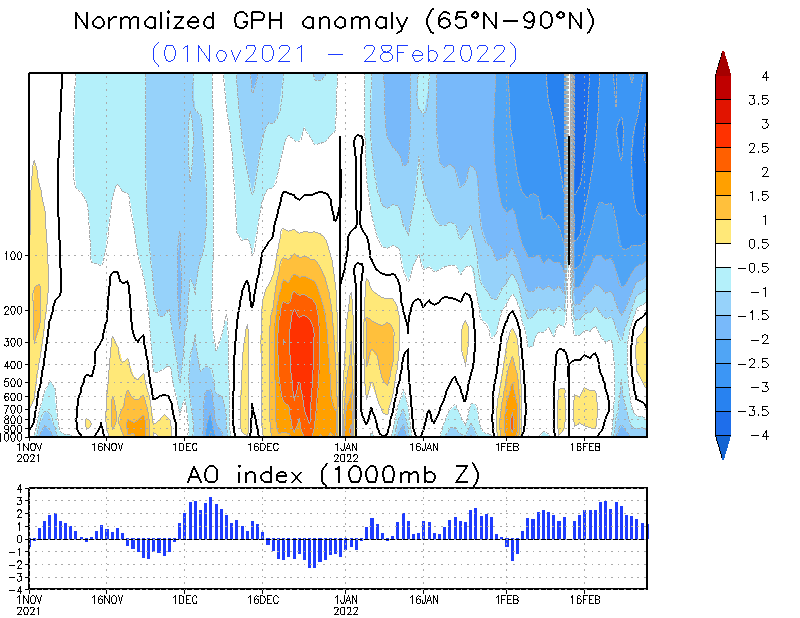
The Stratosphere is warming over the Arctic. That feature correlates very well with sending real cold southward. Therefore any model showing anything more than a temporary warm-up that transits warmth north to build blocks should be questioned.  Below is the current cross-section of the polar vortex. The upper atmosphere warmth is full column.
The Arctic Stratosphere is warming.
This event is highly correlated with mid-latitude cold.
Image Source: NOAA Climate Prediction Center
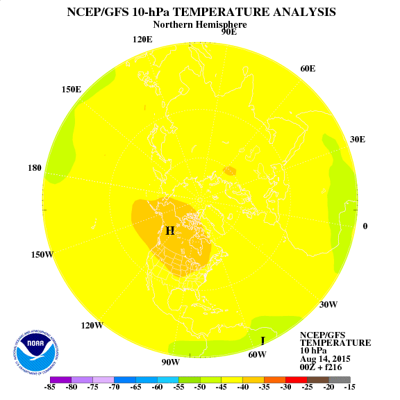
So... what we have right now is a predictor of cold weather to come. Projections support the idea of a terrible middle to end of the month.  
This image is a 10 day projection near the top of the stratosphere showing the warming in the Arctic and cold displaced deep into the US. 

If this projection verifies then the Eastern US is in trouble.
Notice the warm area off the SE Coast, a stormy signal?
Image Source: NOAA Climate Prediction Center.
In previous years this kind of formation has sacked Great Britain and the rest of Europe with some Little Ice Age - like winter weather. Our continent would seem to be overdue for something that severe despite the cold conditions that dominated 2009-10 and 2010-11. While we suffered those years, Europe SUFFERED. 

The question is whether we get some tropical forcing in the West Pacific and a jolt of energy to bring real winter into the Eastern US. I suggest watching Alaska. If that state trends warmer than it would suggest that High Pressure there will push the colder air SE. Another region to watch is Mexico, a persistent jet stream crossing that country from the Pacific would represent a lowering of pressure to draw the cold in and introduce more Winter Storm opportunities.

So, its time to go back to basics. Follow the satellite images and the overall weather to solve for downstream effects, While the Stratospheric warming event is not a perfect correlation to cold here in the SE US ... it is good enough to question weather models that would lead one to believe that winter is dead.

Here is a great New Year's Resolution: Follow actual weather more and models less ....

Monday, November 19, 2012

A Case for a Cold Stormy Winter

A combination of a Negative NAO and Negative AO in October has a strong correlation to Eastern US cold and/or snow.  Those who want to roll the dice on a cold, stormy winter can look to 2002-03, 2009-10 during this decade.   I do have to mention that the indices were strongly positive in October preceding legendary winters like 1977-78.  It is interesting that snowy winters like 1981-82, 1968-69, and 1960-61.  I discounted 1974 because it was a blazing La Nina year.  2006 is an oddity because it was a promising El NIno Winter which the phenomena simply shut down.

So, we have an argument for cold, stormy winter.   The fact that the legendary winters were excluded might be an indicator of the correlation working in 
+AMO (Warm North Atlantic) situation but not so much when it is negative.  There is no such thing as a perfect linear correlation in weather.


Data Source: NOAA Earth Science Laboratory

This composite Temperature anomaly from the NOAA Earth Science Laboratory covers the bonafide El Nino Winters featuring a -NAO/-AO below -1.00 in October (I excluded 2006).  The pattern of cold is what I believe will resemble the upcoming winter.


This is a composite of Sea Level Pressure anomaly.  Take note of the lowest pressure being at the 50N/50W position that argues for my idea that the upcoming season can be dubbed the Winter of the Nor'easters.  50/50 Lows favor snow/ice in NC and VA.  This data is also from the NOAA Earth Science Research Laboratory.

This plot is not dissimilar to the PNA
      That's all for now.  Later this week it will be time to discuss a potentially really cold start to December.


Wednesday, November 14, 2012

Finally! The Winter 2012-13 Forecast

To El Nino or not, Is that really the question?

Here in NC and VA many El Nino winters are loved because they do tend to be colder an usually contain a few good winter storms.  La Nina, on the other hand, is maligned for warm, dry, winters that lead to hot summers full of bugs and pests.   Therefore, the first question usually asked is whether to label a winter as an El Nino or La Nina.

Occasionally we see the crazy La Nina's like 1976-77 and 2010-11 which blocking develops in NE Canada and leads to endless cold.  There are also occasional El Nino's that feature warmth closer to South America that lead to endless gray 40-50 degree rainy days.  Thus, while the labels have some reliable generalities, I think it is a good idea to analyze the whole globe for clues. The fact is that it takes a moderate to strong El Nino or La Nina to rule the roost.

What are the Oceans telling us?

There is always the question of whether the ocean temperatures are being driven by the atmosphere, "Top-Down" , or vice versa (Bottom Up).   A good winter El Nino features plenty tropical storminess near the Dateline.  I find another feature even more interesting.  Look at the Ocean Temp anomalies below:


  1. Warm east of Hawaii, Cold Gulf of Alaska:  This feature appears to be stable and promotes a -EPO.  An indicator of a cool to cold Winter if the signal holds through the season.
  2. Warm pool near Mexico:  Promotes low pressure at that location.  This promotes drainage of cold air from the north and a subtropical jet stream.
  3. Oops!, I skipped 3 but do not want to re-do the Chart :>)
  4. El Nino?:  Sort of.... warm water in the right place to promote low pressure and feed the all important Jet Streams.  I think just enough but not too much.
  5. Cold Water near Darwin, AU:  Tropical cold water promotes High Pressure.  At that location it would mean a downhill slide to #4.
  6. Cold Southeastern Seaboard:  This can be an indicator of cold to come if the water is caused by rain and cool Autumn.It can also be a bummer that promotes NC and parts of VA being skipped instead of targeted by Nor'easters.
  7. Neutral Water near Greenland, ice already east, but warm further south: Too much -NAO snows on LA, MS, AL, FL, GA, and SC, while skipping us.   That signal is very mixed in regards to the NAO.  Winters with plenty of fluctations seem to be the most exciting.  Tough read...
The oceans seem to be indicating a much different Winter than the non-winter of 2011-12.  There are definitely ingredients for a season that is biased cold with enough "El Nino" around to send storms into the Gulf of Mexico to the East.  The cold water near the SE Coast is not something Winter lovers want to see unless it is being caused by the atmosphere ("Top Down") and not given a chance to feedback.   Hurricane Sandy and 2 Nor'easter non-effects on NC and limited in VA has me worried that a Confluence (Skip Zone) might be out there.

Other Signs and Wonders

The beautiful colorful sunsets this autumn and feverish Squirrel activity are 2 observations also supporting a cool to cold winter.  I don't think an acorn from our Oak Tree has even hit the ground!

More Seriously...

While I have my concern,,,,  this appears to be a 2003-04 type winter that  featured 2 snows and a mega-icestorm.  There will be plenty of back and forth swings in the SOI, plenty of frontal passages, and a base state that is cooler than average in the east (-EPO).  I am also impressed by blocking in the West Polar Pacific (called the -WPO) which, if it is stable through winter would provide an ample supply of Siberian air.

So, in a nutshell:

  • At least 2 degrees colder than average.
  • Plenty of storm, opportunities should yield 2-3 disruptive winter storms.  Hopefully the traditional school calender does not end in late June 2013.
  • If we go through December and see NC and VA being skipped by Nor'easter, it will be time to lower expectations about snow,