Showing posts with label Frost. Show all posts

Monday, April 11, 2011

Concerned about damaging severe weather Friday-Saturday

It has been interesting trying to figure out what form the amplification signal provided by the March 31 and April 1 surge in the SOI.  Finally there is some model agreement on a scenario that I think fits the current climate's tendency for wild weather events.

An intense storm system is expected to deepen over the central Plains and move NE dragging both upper level cold and a strong frontal system through our region. It is bad enough that a cold front is going to ram into unseasonably warm air.  Upper level cold enhances probabilities of hail, damaging wind, and tornadoes.

Here are 2 projections of what could happen in the Friday evening - Saturday time frame:

  • GFS - Depicts a deepening system headed to the Great Lakes with a negatively tilted, trailing front which would bring the biggest risk of severe weather to VA and points north.


  • ECMWF - Storm follows a track just south of the Great Lakes to the NE US.  This scenario has more cold air behind it.
We will need to keep an eye on the situation this weekend.  Another update will occur as we get closer to the event.

Monday, April 4, 2011

Super high SOI signalling dramatic weather ahead?

The Southern Oscillation Index is based on the difference in surface pressure between Darwin, AU and Tahiti related to the tendency up or down.  Negative numbers and/or falling tendency signals a progressive (west to east) weather pattern.  In this case the index soared to 74, the highest I have seen, signaling an amplified (north-south) and often a blocked pattern.  The chart below shows that this occurred on April 1st. 
SOI soars to 74 on April 1st
Data Source: The Long Paddock
Computer models are showing no specific events today here in Central NC and VA on April 14-15.  This is not a surprise as models have been simply terrible through this La Nina episode.  I think that the GFS shows an interesting intense storm in the Plains that would be a headline maker if its true.
April 14 GFS - Very cold airmass dominates the east.
Count the number of sub 1000mb storms on the map!

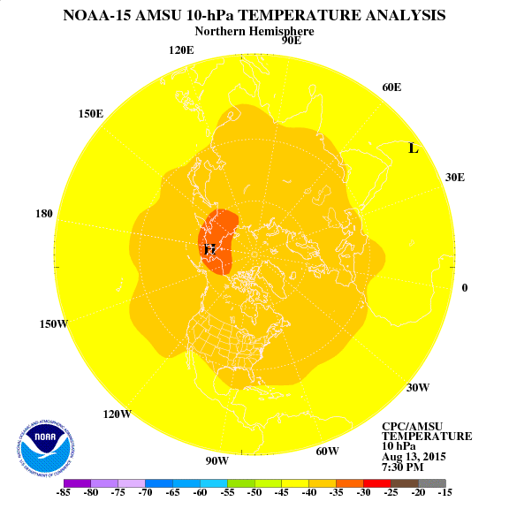
One clue that the cold air mass affecting the east beginning at the middle of this month has a lot of merit is the strong warming event in the Stratosphere advancing from Siberia to the Pole.  Such an event acts like a plunger pushing arctic air into the middle latitudes.  Unfortunately cold air surging into the the typical gyrations of spring further south is a recipe for severe storms, frosts, and freezes.
Sudden Stratospheric Warming (SSW) advances toward the Pole.
Source: NOAA Climatic Prediction Center

So, interesting days lie ahead.  You can definitely that I will be paying close attention to weather developments and will keep you informed.

Tuesday, March 22, 2011

Big Weather Weekend for Eastern US

Even though Meteorological Spring runs March-May the season arrived yesterday for everyone else.  Here in Central NC and VA the sun was out, temperatures warm, daffodils blooming beautifully, and the TEMPTATION to get summer garden plants in the ground.

Two weeks ago a high pressure ridge setup in east central Asia which displaced Siberian air into North America.  Fortunately a stubborn heat ridge over Florida will blunt the worst of the cold here in the Southeast but areas north of Fredricksburg, VA are about to get buried in an early spring snowstorm.

Big storm complex is nosing SE.
Source: Univ of Wisconsin SSEC

The first storm will dump snow in the Northeast tomorrow.  The training front is windy and fairly dry but should be watched for severe thunderstorm development as it approaches NC and VA.

This weekend features the MAIN Event as Cold high pressure feeds another storm system and forces it to take a southern route.  How far south will dictate whether the snow line can reach Fredricksburg, VA and even press a bit south.  NC and the southeast will face a threat of severe thunderstorms.

GFS and other models depict deepening storm pushing east,

Following the passage of the storm I am very concerned about a frost threat, even a freeze.  My recommendation is to delay planting of summer vegetables until at least April 10.  The weather pattern is shifting to a warm west and cool stormy east.  It is best to allow the cool period to resolve itself then look at mid April to set possible planting dates.

Thursday, November 11, 2010

Another Weekend, Another frost

Time to protect the pepper bushes once again.  Frost the next couple of nights will be the product of very dry air, common in November and not a polar or arctic blast.  Frosty mornings will give way to sunny skies and 65-70 degrees Saturday and Sunday. 

Dry air cools quickly once the sun sets and by morning 30-35 degrees colder than the previous day's highs are not that uncommon.  November is the driest month of the year in Raleigh, NC.  The length of nighttime plays a role also as we approach the darkest 2 months (Nov 21-Jan 21).

After another week of mild dry weather there is expected to be a major weather pattern change for the week of Thanksgiving.  This GFS forecast from NCEP depicts a cold high pressure system damming air down the Eastern Seaboard.  Such a pattern will certainly be colder than average and is one that would favor precipitation as warm air aloft would tend to overrun.
GFS Forecasts wedge of cold air dominating the eastern seaboard.
Source: NCEP Central Operations