Showing posts with label SOI. Show all posts

Monday, April 11, 2011

Concerned about damaging severe weather Friday-Saturday

It has been interesting trying to figure out what form the amplification signal provided by the March 31 and April 1 surge in the SOI.  Finally there is some model agreement on a scenario that I think fits the current climate's tendency for wild weather events.

An intense storm system is expected to deepen over the central Plains and move NE dragging both upper level cold and a strong frontal system through our region. It is bad enough that a cold front is going to ram into unseasonably warm air.  Upper level cold enhances probabilities of hail, damaging wind, and tornadoes.

Here are 2 projections of what could happen in the Friday evening - Saturday time frame:

  • GFS - Depicts a deepening system headed to the Great Lakes with a negatively tilted, trailing front which would bring the biggest risk of severe weather to VA and points north.


  • ECMWF - Storm follows a track just south of the Great Lakes to the NE US.  This scenario has more cold air behind it.
We will need to keep an eye on the situation this weekend.  Another update will occur as we get closer to the event.

Monday, April 4, 2011

Super high SOI signalling dramatic weather ahead?

The Southern Oscillation Index is based on the difference in surface pressure between Darwin, AU and Tahiti related to the tendency up or down.  Negative numbers and/or falling tendency signals a progressive (west to east) weather pattern.  In this case the index soared to 74, the highest I have seen, signaling an amplified (north-south) and often a blocked pattern.  The chart below shows that this occurred on April 1st. 
SOI soars to 74 on April 1st
Data Source: The Long Paddock
Computer models are showing no specific events today here in Central NC and VA on April 14-15.  This is not a surprise as models have been simply terrible through this La Nina episode.  I think that the GFS shows an interesting intense storm in the Plains that would be a headline maker if its true.
April 14 GFS - Very cold airmass dominates the east.
Count the number of sub 1000mb storms on the map!

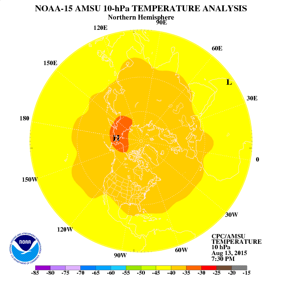
One clue that the cold air mass affecting the east beginning at the middle of this month has a lot of merit is the strong warming event in the Stratosphere advancing from Siberia to the Pole.  Such an event acts like a plunger pushing arctic air into the middle latitudes.  Unfortunately cold air surging into the the typical gyrations of spring further south is a recipe for severe storms, frosts, and freezes.
Sudden Stratospheric Warming (SSW) advances toward the Pole.
Source: NOAA Climatic Prediction Center

So, interesting days lie ahead.  You can definitely that I will be paying close attention to weather developments and will keep you informed.

Saturday, February 5, 2011

Before the warm comes terrible cold and storm!

The buzz about the potential for a east coast winter storm has become a rumble.  After the Dec 26 computer model debacle I have kept a healthy scepticism as La Ninas often feature "phantom snowstorms" in projections. 

Deep snow and terrible cold from Mexico through the Great Lakes was last week's big story.  My friends in Chihuahua, MX received a rare snowfall which covered the roads and temperatures reaching -1 F and a Thursday high of only 23, 42 degrees below the 65 F average high!  New Mexico and South Texas were heavily impacted by similar cold which drained power and natural gas supplies to critical levels requiring rolling blackouts and gas pressure outages.  Imagine temperatures near 0 and no way to heat your home!  Power and gas outages also impacted northern Mexico in a similar fashion.

It appears that Old Man Winter is in a foul mood and is set to target the East with a POTENTIAL monster storm and another serious drainage of Arctic air.  The only good news that can come from such an extreme event is how the high pressure which pushes the dome of cold air into our region often stalls in the south and warms up!  My confidence is very high that the days around Valentine's Day will be warm ... the only threat to 60+ highs being reduced if heavy snow is included with the cold.

One of my key tools which correlates very well to dramatic weather is the daily Southern Oscillation Index (SOI).  In my opinion the 2 day crash to slight negative readings on Jan 26-27 which is both preceded and followed by much higher values is a big warning that the tropics plan to participate in the event. 

Here is a European Model forecast which IF CORRECT would lead to a serious winter storm for the entire east coast.  I have added some notes to the forecast.  As usual, the exact track of the storm means everything.  Whoever ends up in the snow zone will get buried. Local Meteorologist Allan Huffman commented today that extreme projections include a 1-2 foot snowstorm followed by low temperatures near 0.
A ECMWF Perfect Storm
The upcoming week will likely be very busy.  Please expect to have your hopes and fears really stretched by computer models which go back and forth with all kinds of storm and cold projections. 

Friday, October 15, 2010

Signal from down under may be a weather warning

My favorite Fall and Winter tool is following the antics of the Southern Oscillation Index (SOI).  During the fall following rises and falls can be useful in anticipating the moveme

Strong positive readings have dominated since the summer.  Such values are indicative of a La Nina circulation featuring blocked weather patterns and enhanced North Atlantic and West Pacific tropical activity.  Here in NC and VA we can thank the circulation for summer's endless heat.

Recently there was a nosedive in the index which also was part of the rise in global AAM and burst of equatorial westerly winds noted earlier this week.  The dip and steep rise indicates the likelihood that the surge of momentum will come to a screeching halt near the SE around Oct 28.  This kind of pattern usually is a great warning of an extreme or unusual weather event.  My suspicion is that a strong cold front and possibly interaction with a storm system will complete the destruction of summer.
Data Source: The Long Paddock