Thursday, October 28, 2010

Typhoon trough will mean business next week

Typhoon Chaba turned NE earlier today and is expected to continue in that direction past Japan.  Therefore we set the clock 6-10 days and can expect a trough that will mean business in terms of cold with staying power.  I expect that unprotected summer vegetables will also meet their demise bu next weekend.
Typhoon Chaba signals coming of
Full Latitude trough to eastern US.
Source: Joint Typhoon Warning Center


Do the computer models agree?  The US Global Forecast System predicts a strong Nor'easter moving up the coast next Thursday.

     The ECMWF's storm system is much faster, exiting it on Wednesday evening and is not as strong.  I like its prediction of a full latitude trough much better than the GFS.
     The 2 models agree on a storm system and a trough.  We have less than a week to figure out which will be the big weather story...  It could be a double whammy!

Prospects for Frost Saturday Morning

Cold dry air is moving into our region tomorrow.  This sets the stage for North Central VA, particularly west of I-95 and North of Richmond to receive the first frost of the season.


Here in Central NC there is the possibility of light frost on cars and elevated surfaces.  I expect that those of us with ripening tomatoes and peppers will be able to give them almost another week.  Below is the National Weather Service's projected 8 AM temperatures for Saturday morning.  Based on last week's behavior of Typhoon Megi I agree with the idea of a marginal frost situation.

Wednesday, October 27, 2010

Tornado Watch in Central VA, Threat shifted north overnight

Massive circulation dominates the satellite image
Source: Univ of Wisconsin SSEC

Our neighbors in Central VA are under a Tornado Watch this morning as heavy thunderstorms target the region.  Here in Central NC we will sit out this round of storms.

The massive storm over the midwest continues to rage.  This morning's water vapor image looks like science fiction.   

Tuesday, October 26, 2010

Concerns for Overnight Severe Weather

While taking Bella out I noticed clouds at different heights moving at different speed and direction compared to wind at the ground.  Combine the wind shear with heat and humidity and factor in a strong incoming cold front and it raises the risk for severe thunderstorms, high winds, hail, and tornadoes significantly.

A massive superstorm raging in the upper midwest has a trailing cold front which will pass through the SE US later tonight.  The anvil shape is disconcerting.  

Incredible storm centered near the Great Lakes
also threatens East with Severe Weather.
Source: Univ of Wisconsin SSEC
     Be safe tonight!

Thursday, October 21, 2010

Oct 28 Cold will Blast then Pass

The weather event scheduled on or shortly after Oct 28 now has some detail that can be added.  Last week the signal that something is coming came from Darwin, AU and Tahiti.  This week the expected path of Typhoon Megi provides more detail.

How does a West Pacific typhoon help us here in NC and VA?  It clearly defines the shape and extent of the oceanic ridge of high pressure and on occasion the exact timing of passing mid-latitude troughs.  Waves in the atmospheric circulation then can be observed crossing the Pacific ocean with no interference from land masses.

The track of a Typhoon indicates whether a ridge or a trough will
be in the Eastern US in 6-10 days.

Typhoon Megi is expected to turn east of north for about 2 days before turning NW and hitting land.  If this scenario is correct a cold front will draw the storm system N and NE but fail to be strong enough to hold on.

Joint Typhoon Warning Center forecast for Typhoon Megi

Therefore my expectation is that a strong cold front will pass through the eastern US near Oct 28th but the associated cold air will blast in and lift out in 2-3 days.   If we are fortunate, perhaps the rapid movement of the system will prevent frost from ending summer tomatoes and peppers (Yes, I have 11 tomatoes!!!).  Do the models agree? Here is the GFS depiction of a front passage near Oct 28 and cold high pressure.

Arctic Vortex in Central Canada is expected to retrograde (move westward)
Cold air masses must go around then underneath.

Sunday, October 17, 2010

Fall/Winter Gardening, Why stop when its frosts?

Why stop when it frosts?

Thanks to book loaned to me by a good friend almost 18 months ago I learned that the joy of gardening does not stop when it frosts.  In fact, one cool season vegetables are established and a typical NC winter sets in there are no bugs, very little maintenance, and plenty of tasty Italian mixed Greens, Beets Kale, Spinach, <green> Garlic, Carrots, and other root crops.  The book by Eliot Coleman is called Four Season Harvest.

One of the principles which I learned is that it is good to pay attention to what God is serving in each season.  Greens and root crops are rich in anti-oxidants and minerals which benefit people by bolstering our immune systems and speeding recovery from winter colds and flu.
Insalata Odorosa - We have already eaten a few bowls.
Swiss Chard and Beets got a slow start no thanks to September's heat.  Now that it is cooler and I added some fertilizer the plants are on the move and will keep growing as long as temperatures stay above 27 degrees.  Swiss Chard will go dormant below 27 and re-awaken in the spring.  Beets are great when cut into strips and sauteed in a cast iron skillet in butter/coconut oil mix.  Add a dash of sugar and cook until the edges are crispy!
Rainbow Swiss Chard and Detroit Red Beets
      Spinach and Buttercrunch Lettuce are also delicious and have a great tender taste once temperatures drop.  The Lettuce will need to be eaten before a hard frost.  Spinach keeps on coming all winter long....
Viroflay Spinach and Buttercrunch Lettuce
     Kale tastes best after a hard frost and will also thrive in cold.  Another friend introduced us to the idea of making Kale hips by lightly oiling the leaves and baking them at 350 on a cookie sheet.  If that does not work out then Kale still tastes good in salads or sauteed,
Dwarf Kale is behind the Insalata Odorosa
     The next 2 weeks is garlic planting time!  Plant 1 clove every 4" and fertilize with compost and a pinch of 0-45-0 super phosphate.  Garlic can be picked green during the entire winter.  The roots that survive (because you have not eaten them yet) through next june will reward you richly with unbelievable tasting mature garlic!

    Sad you missed out?  Plant your garlic now and get your lettuce, chard, spinach ...etc... planted around March 1 for the Spring cool season campaign.

Friday, October 15, 2010

Signal from down under may be a weather warning

My favorite Fall and Winter tool is following the antics of the Southern Oscillation Index (SOI).  During the fall following rises and falls can be useful in anticipating the moveme

Strong positive readings have dominated since the summer.  Such values are indicative of a La Nina circulation featuring blocked weather patterns and enhanced North Atlantic and West Pacific tropical activity.  Here in NC and VA we can thank the circulation for summer's endless heat.

Recently there was a nosedive in the index which also was part of the rise in global AAM and burst of equatorial westerly winds noted earlier this week.  The dip and steep rise indicates the likelihood that the surge of momentum will come to a screeching halt near the SE around Oct 28.  This kind of pattern usually is a great warning of an extreme or unusual weather event.  My suspicion is that a strong cold front and possibly interaction with a storm system will complete the destruction of summer.
Data Source: The Long Paddock

Monday, October 11, 2010

Atmospheric "Bull Market" signals more extreme weather

Important Reference: Putting a Spin on the Earth's Weather

El Nino's grand collapse this past spring into a dominant La Nina pattern was very similar to a Stock Market Crash in terms of the mayhem caused worldwide.  Weather patterns literally locked in place causing some of us to roast, others, to shiver, and areas like Pakistan to drown in rainfall.  An extremely interesting aspect of this La Nina was the global lack of hurricane production.  Even though the Atlantic was well above average the total cyclone production as calculated in terms of Accumulated Cyclonic Energy (ACE) is at a 33 year low.

Global AAM just got a boost as mountain ranges are literally moving weather systems along in the deep tropics.  Far to the north blocking high pressure formation is being promoted.  This development is very important for 2 reasons:
  • A destruction of the repetitive heat ridge which caused suffering in the US Southeast. Summer will soon be OVER.
  • Easterly flow to the north combined with westerlies to the south encourage storm formation.  We need to be on the lookout for a Nor'easter or tropical hybrid which brings wind and rain to the east.  Another big reason to watch for a big storm is the coming of the NC State Fair!
This pattern looks like last winter.
Source: NOAA Earth Science Research Laboratory.


 Compare the above image with the one below which I saved from this past winter.  Keep in mind that the Winter's biggest story was the -AO mega blocking pattern which sustained cold more-so than the El Nino.
Winter 2009-10 featured fully developed versions of
blocking in the North and a subtropical jet to the south.
Source: NOAA Earth Science Research Laboratory.

     The GFS Model does forecast a blustery frontal passage for Thursday,  Just in time for the start of the NC State Fair.

That's not "Fair"!!!
Source: NOAA Air Resourced Laboratory


     The last GFS Model Output needs to be interpreted in terms of overall theme.  Models at the Day 10 level can be notoriously wrong   The scene depicts a heavy rainstorm ahead of an incoming strong cold front that washes the NC State Fair away.  I think something like this is coming BUT will need to tweak the timing as actual weather systems appear on the map.
More of "That's not Fair"?
Source: NOAA Air Resources Laboratory

         Could this kind of a weather pattern repeat during the upcoming winter?  I am finding that Autumn events seem not to correlate very well with the following season.  The picture that God is painting through the transition of Fall does shine some light in terms of the overall theme of the events and measurable impact on the global circulation.

Friday, October 8, 2010

Summer 2010 Roundup

Hottest on Record!

Is it possible to complain enough about this past summer?  In addition to being the hottest on record I cannot remember a summer season which featured such long stretches of extreme heat with no relief! For your reference here was my Summer 2010 and Tropical Outlooks.

The idea of large scale land based blocking patterns was easy derived.  It was challenging to figure out that NC and VA would be in the heart of the heat wave as I oscillated between the idea of a cool and hot summer last spring.  The final result was hotter than my very uncomfortable idea of 2-3 above average.


Source: National Climatic Data Center
It is easy to see that the areas specified as being hot were really close to being correct. It would have been great to have been more accurate about the heat BUT warnings of long hot and dry stretches during the season was a great description.

A Drought which mathematically did not happen

Rainfall amounts were near 69% of average at the airport.  I must point out that RDU was a bit dry (.47") on August 24th when the Garner, NC Weather Station reported 4.77"!  So even though overall we were nearer to average than a drought the oppressive heat and long dry periods led to a gardening season which was extremely challenging.  My end of summer flooding concerns were certainly vindicated by the near 6" deluge at the end of September.  On a national scale there was no dominance of drought when total rainfall was considered.


Source: NOAA Earth Science Research Laboratory

Tropical Storms gobbled up by King TUTT

Persistent low pressure in the Atlantic combined with persistent upper level SW flow led to a season which started quietly before EXPLODING in late August.  Here is the Unisys site showing the storm tracks.  Earl was closest to NC as he passed just offshore of Cape Hatteras as he was weakening from a Cat 4 to a 2!  He illustrated my concern that storms that would fail to stay far out to sea would be monsters.  Florida avoided a big hit (so far) and Earl was our closest brush to a major hit.

Therefore the dominant storm tracks and expectation of a late starting season was very correct.  Risk to Florida has not yet materialized and may not...  Earl was wide right of Cape Hatteras.  My projected number 12 was low as the storm total is 15 (even though Bonnie, Colin, Gaston,  and Nicole were pretty lame classifications).  I admit that my 12 number included a couple of named storms by the Tropical Prediction Center which would be questionable.


Summer by the numbers (RDU)

Source: National Weather Service
  • Ave temperature, 81.7 was a scorching +5.1 anomaly, record hottest!!!
  • At 92 the average high temperature simply unbelievable.
  • Rainfall was 69% of average. 8.06"
  • Cooling degree days reached an EXPENSIVE 1555 which was 50% aboverage average.
  • Counting was difficult.  It appears that 8 Record high minimums were set and 3 record highs.  It was amazing to observe mid to upper 80's as late as 11PM across the area on several occasions.
I am extremely glad that Summer 2010 is now history.  In 42 years of life I cannot recall suffering so much in one season.  It was no fun to be outside hardly at all.

There was one benefit to the awful summer.  Every other day was Christmas on the Cayenne bush!

Wednesday, October 6, 2010

Winter 2010-11 Preview - Did La Nina just hit bottom?

The most frequently asked question to me during the past few weeks is about what to expect this winter.  2009-10 was extremely cold and in some parts of the deep south the coldest on record.  Among the biggest concerns of questioners has been related to whether that level of cold will repeat this year.
Often the focus each winter is the state of the 
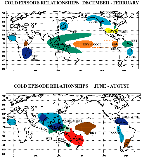
El Nino/La Nina Southern Oscillation (ENSO). Many of you know my annoyance at mainstream forecasts which display a map like the one below and walk away believing that the public has been served.   Ladies and Gentlemen, it is often stated "The Devil is in the details".

 
Stereotypical La Nina Relationships
Source: Wikimedia Commons

Here is a detail, which if it becomes true will make a huge difference between a stereotypical mild and dry winter for Central NC and VA and something much different.  When La Nina's effects on global circulation reach a bottom in mid or late season then the "boring" winter usually wins.  What happens if the bottom is reached during the preceding autumn?  Did this La Nina episode just do that?


Source:  Earth Science Research Laboratory
In addition to a probable early bottom of La Nina we must also factor in the ongoing extended period of low solar activity. While sunspots and solar flux have risen above the doldrums of the long minima between cycles 23-24 it has not risen much at all. Based on historical evidence of low solar activity correlating very well with extreme weather and cold winters there is concern that if the sun does not return to higher levels of activity that another Ice Age could develop.

Extreme winter events in the Southern Hemisphere is a cause of concern. There was the massive cold wave which swept South America.  The cold devastated fish populations, livestock, and killed people.   Snow and sleet was observed in tropical regions and the cold actually crossed the equator !  Recently spring blizzards raged in New Zealand for six days. Over 350,000 lambs were estimated to have been killed by the weather.

Another variable is the ongoing but lower level volcano activity in the high latitudes.  Such activity will certainly reinforce the propensity for blocking patterns which has caused global grief this year in the form of prolonged extreme weather.  If the Katla volcano blows its lid in Iceland then the risk of dangerous winter cold engulfing much the the US and Western Europe would rise significantly.

How do I see Winter 2010-11 based on an Autumn bottom of La Nina?
  • Overall average temperature a little colder than neutral BUT getting there by wild swings in temperatures.
  • Last year's cold was persistent and costly.  2010-11 should include shorter periods of extreme cold.  It would not surprise me if Central VA and NC experience periods of unbelievable cold with lows below 15.
  • There will be breaks in the winter action.  Keep some short-sleeved shirts handy.  Perhaps even some time to get a January tan! (70's) . But unlike last winter we will get some real warm spells.
  • Not as much persistent snow in VA.  BUT...  If one wants to roll the dice for blockbuster winter events then this is a good year to do it.  IF the weakening La Nina thesis works then there will be at least one period where arctic cold and the southern jet stream can produce a memorable or historic period of weather. 1995-1996 and 1999-2000 had seasons which appear similar to this one. I am not sure how 1935-36 might correlate.  35-36 was a snow blockbuster for our region and featured a persistent negative NAO.  That being said ...  snow in the Raleigh area is episodic, therefore cannot be predicted using statistical averages.  Our propensity for sleet and freezing rain can conceal bad winters because we do not count all frozen precipitation. 
Therefore I believe that exciting but challenging weather lies ahead.  If it is discovered that the La Nina circulation deepens further instead of weakening as winter commences then the final forecast will be kinder and gentler.